rivers.run: River Information and Paddling Expertise
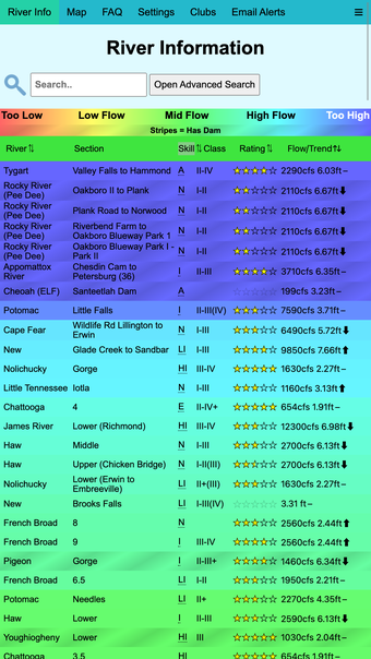
Rivers.run is a free iPhone lifestyle app that provides detailed water levels, water temperature, and other essential information gathered from over 12,000 gauges. It combines this data with paddling expertise from the community to offer insights into river heights and skill level estimations. Utilize GPS coordinates to locate nearby rivers, search based on water levels, skill requirements, names, and ratings, along with user tags and dam releases to discover suitable whitewater or flatwater rivers for your paddling adventures.
The app's maps assist in finding rivers in specific areas and aid in navigation. By clicking on a point, you can access comprehensive details about the river, including flow, temperature, and more. Additionally, an optional weather view lets you track current rainfall locations. River flow data is currently sourced from USGS, NWS, and the Meterological Service of Canada, with plans for more gauge sources in the future.